Travelling Worm

A bookworm's travelogue

Category: new south wales

  • Dobroyd Head walk in Sydney Harbour

    In this post: The scenic track from Balgowlah to Dobroyd Head, part of the Spit Bridge to Manly Walk.

    This is the blog of Mark Wordsworm, the travelling worm. I’m a 40-year-old bookmark (give or take a few years) and I proudly boast my own Hallmark serial number, 95 HBM 80-1. You’ll probably want to read all about me and my Travelling Companion (the TC).

    Today’s travel notes

    Me and the TC (bless her cotton socks) have often ambled down Forty Baskets Track in Balgowlah, braving the beach crossing to continue along Reef Beach Track and up the steep steps of Dobroyd Head Track. At the top of the head, near Tania Park, we do an about turn and take the welcome downhill track back to Balgowlah. This post shares some of the beauty of the area and a few bits of local interest.

    The book I’m in

    Shadow Captain by Alastair Reynolds. I’m chomping through this book at the speed of light. It’s a fast-paced space opera in the best tradition of the genre. Shadow Captain follows on directly from part one of the series, Revenger. This worm will be urging the TC to get hold of the next book in the series.

    Travel tips

    Put on your walking shoes (all six of them, in my case) and take a walk on the bright side.

    The photos

    Me and Peg finding a firm footing at Reef Beach, alongside the Dobroyd Head walking track on the shores of Sydney Harbour:

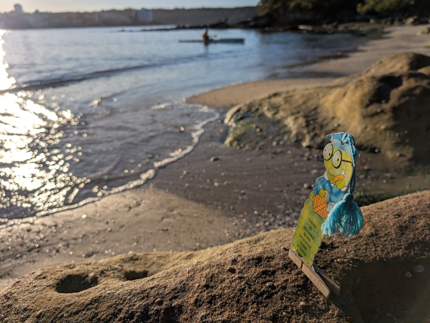
    Like many of Sydney’s beaches, Reef Beach is often reshaped by the tides. The sand moves from one end of the beach to the other, covering and uncovering rocks, exposing channels, and generally changing the area’s appearance. Sometimes it’s quite a leap from the last step down onto the sand. At other times you scratch your head and think, “I could have sworn there were more steps going down to the beach”.

    If the TC gets up early, as is her wont, we catch the sunrise over Forty Baskets Beach:

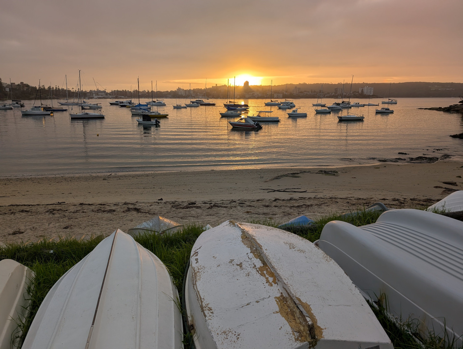
    “Forty Baskets” is an odd name for a beach. The tale that this worm has heard most often is this: the name refers to 40 baskets of fish that the local fishermen collected way back in 1885. Their goal was to feed a large group of soldiers who’d returned from war in Sudan, only to be hustled into the nearby quarantine station to recover from various infectious diseases that they’d acquired while overseas.

    However, that lovely tale of baskets, fish, and deserving troopers might not be true. The Daily Telegraph has conducted some in-depth research and discovered that the beach was referred to as Forty Basket Beach even before the fishermen’s generous collection. And yes, observant reader, it was Forty Basket (singular) not Forty Baskets. After further digging, the Daily Telegraph finds that the word “basket” was in those days used as a measurement (like the word bushel). We often use the singular when referring to a measurement. For example, a two metre pole or a ten tonne truck. The article is worth a read.

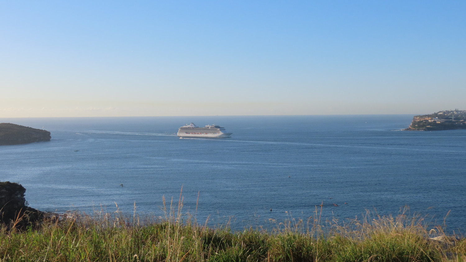
    The harbour views on this walk are spectacular. This photo shows a passenger liner making its way into Sydney harbour through the gateway formed by North Head (on the left) and South Head (on the right):

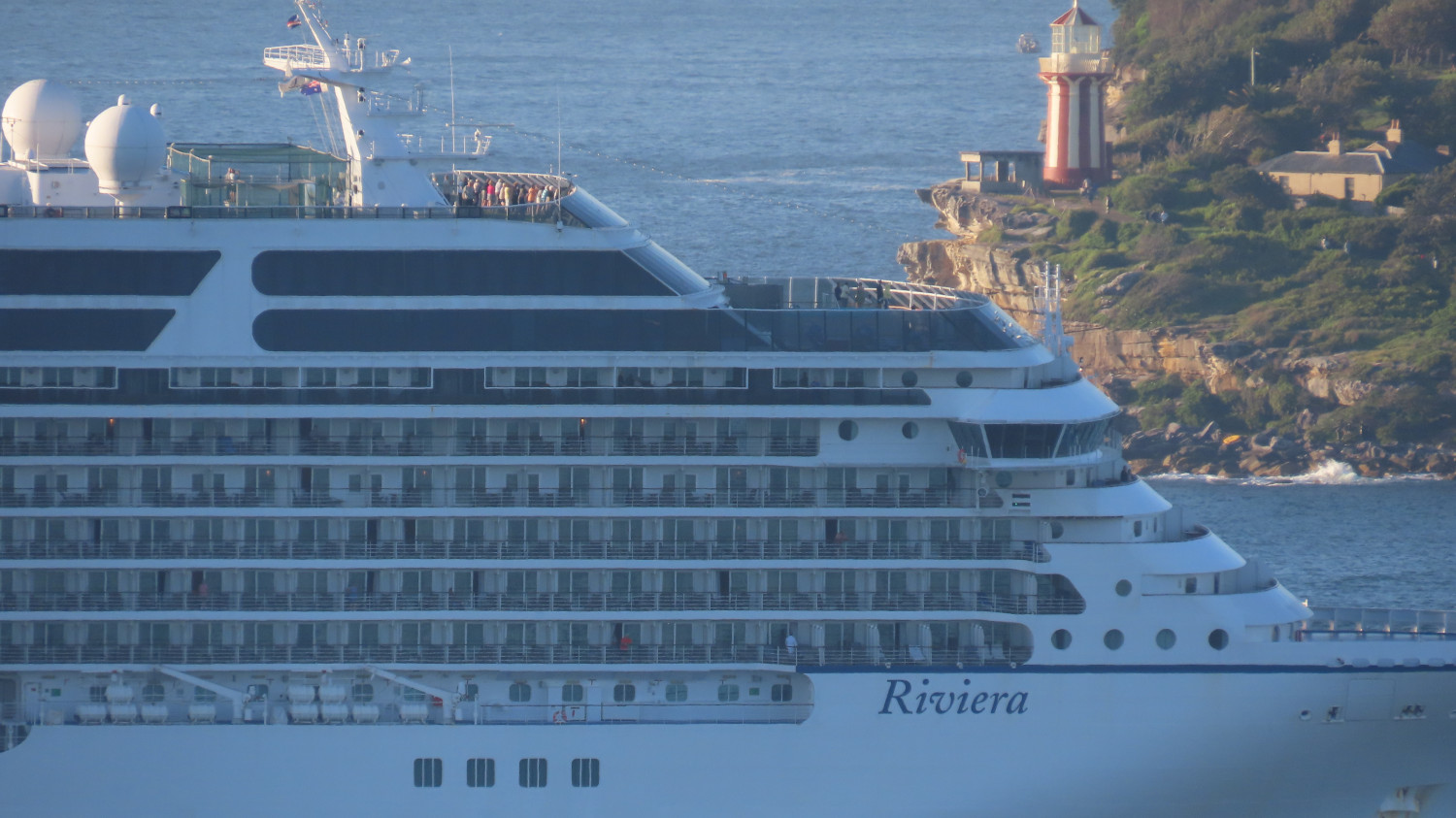
    Let’s take a closer look at the passenger ship. Behind it stands Hornby Lighthouse on South Head. The lighthouse opened in 1858, the third lighthouse to be built in New South Wales. A few of the ship’s inhabitants group together in the viewing platform on top of the ship’s tiers to experience the harbour entry:

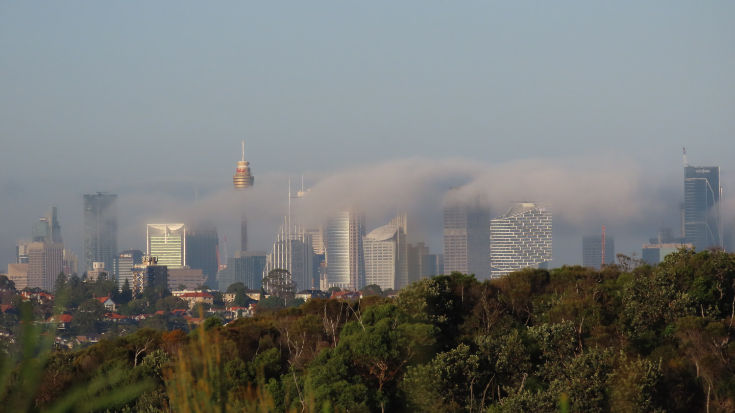
    Sydney city seen from Dobroyd Head, with the sun burning off the early morning mist:

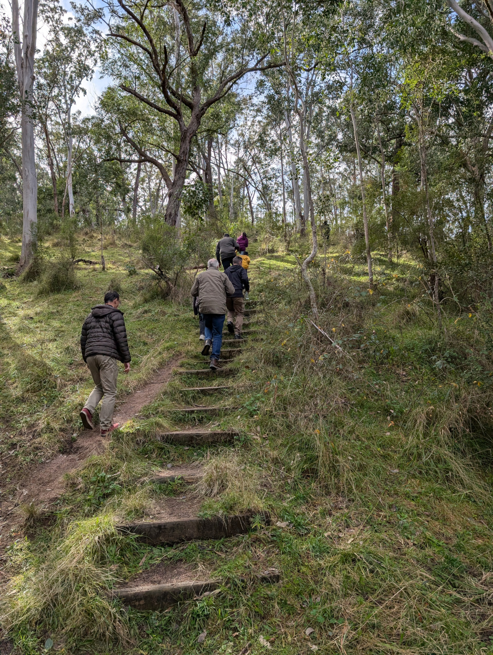
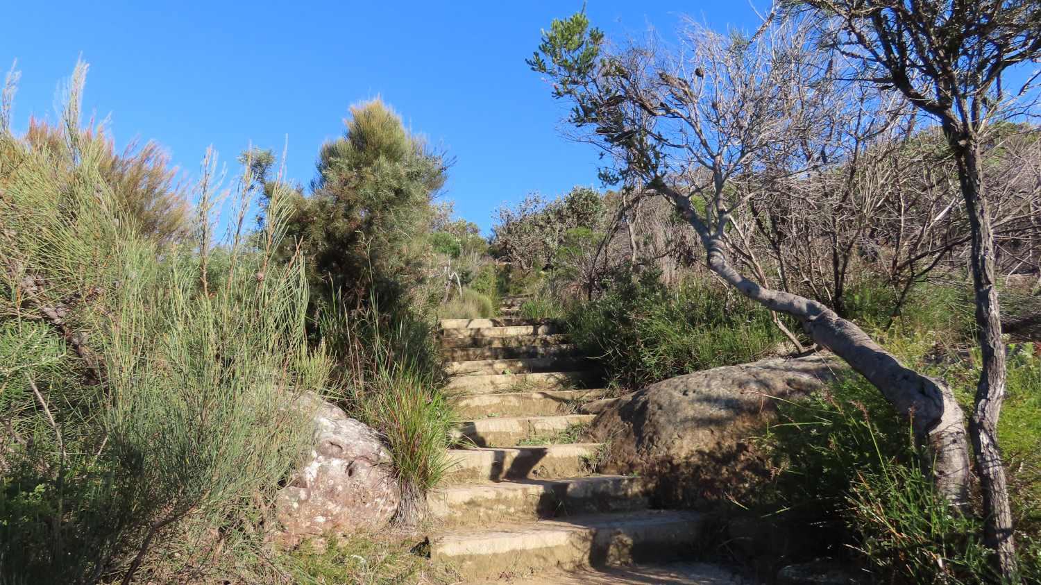
    The path is steep at times. Irregular steps provide good exercise for those quads and calves — for those of you with fewer than six legs, anyway:

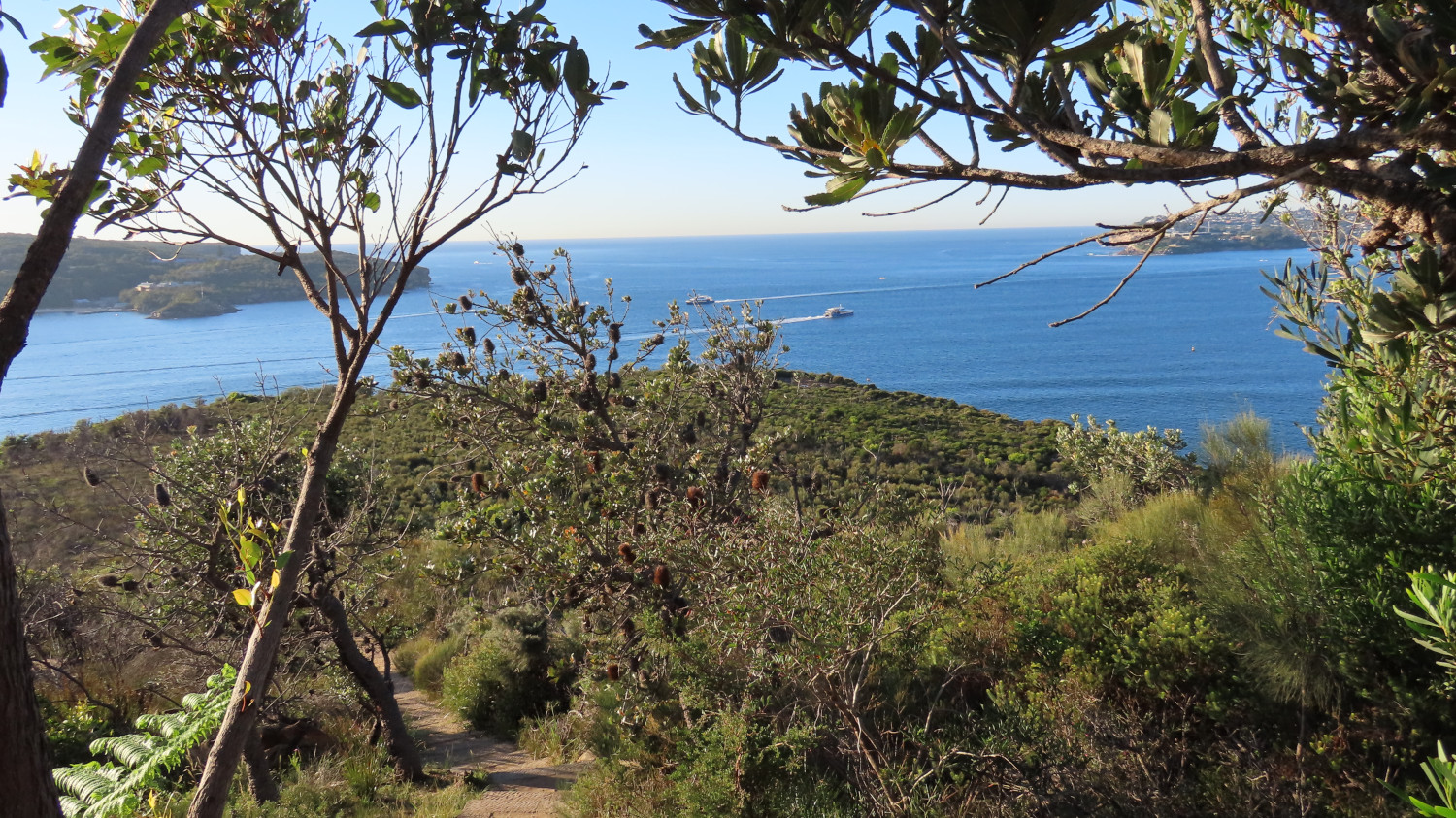
    If you need a breather, turn around and take in the view. You might see the Manly ferries passing as they make their way between Manly and the city. The two in this picture are the privately-run Manly Fast Ferries (as opposed to the slightly slower and more traditional yellow and green boats of the Manly Ferry public service):

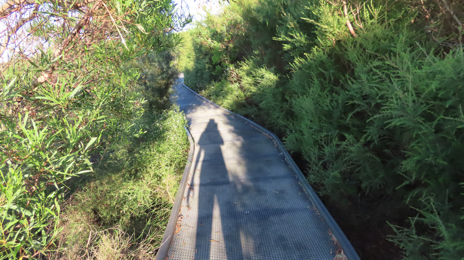
    After the steep climb, a more leisurely path awaits you, sometimes open to the views and at other times walled by bushes and flowers:

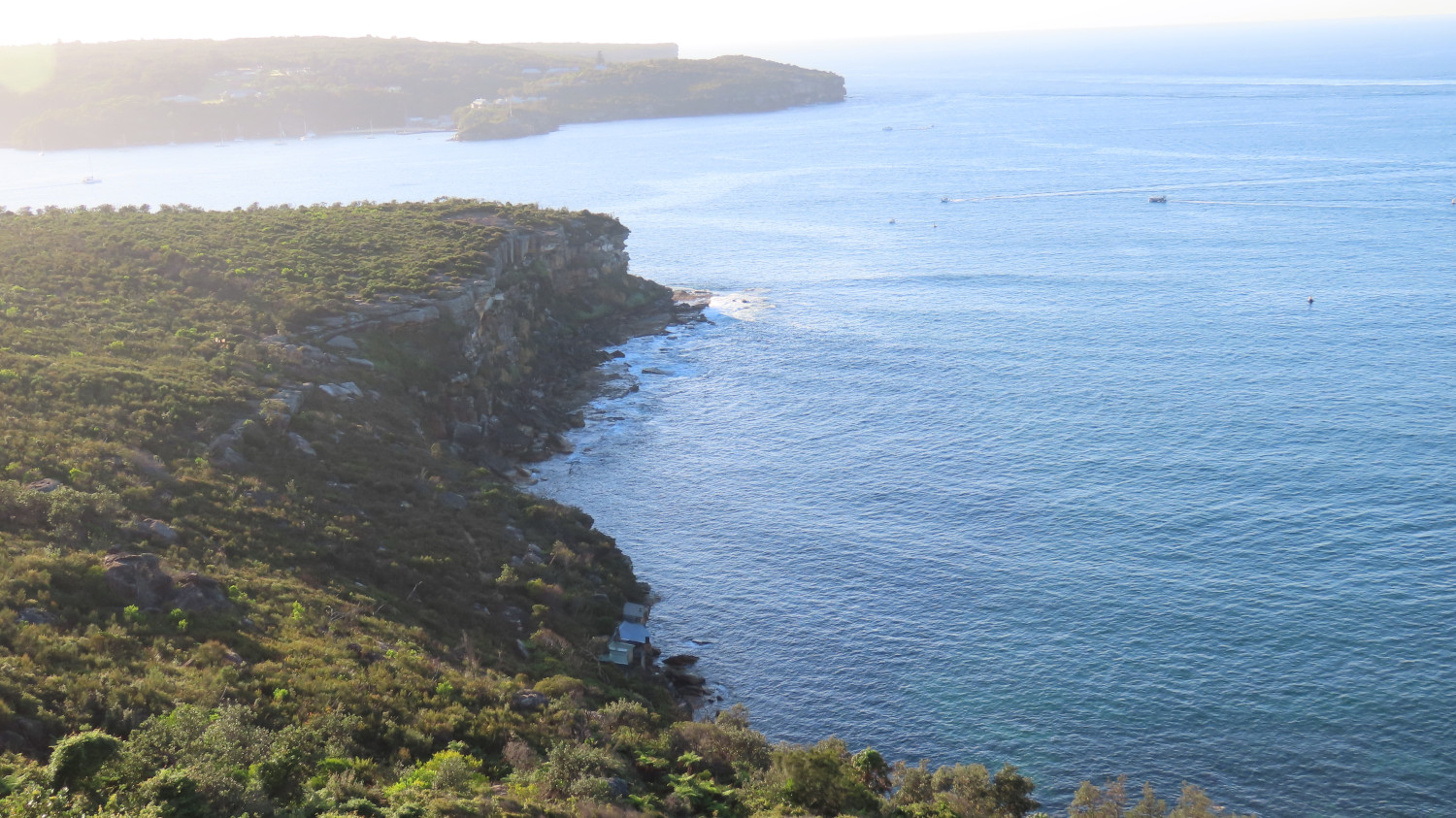
    The viewing point just below Tania Park offers another stunning view of the harbour entrance. In the next picture, just North Head is showing in the background, with Dobroyd Head stretching out in the foreground. Down below, those with an eagle eye can spot the historic huts of Crater Cove:

    Let’s take a closer look at some of the huts of Crater Cove:

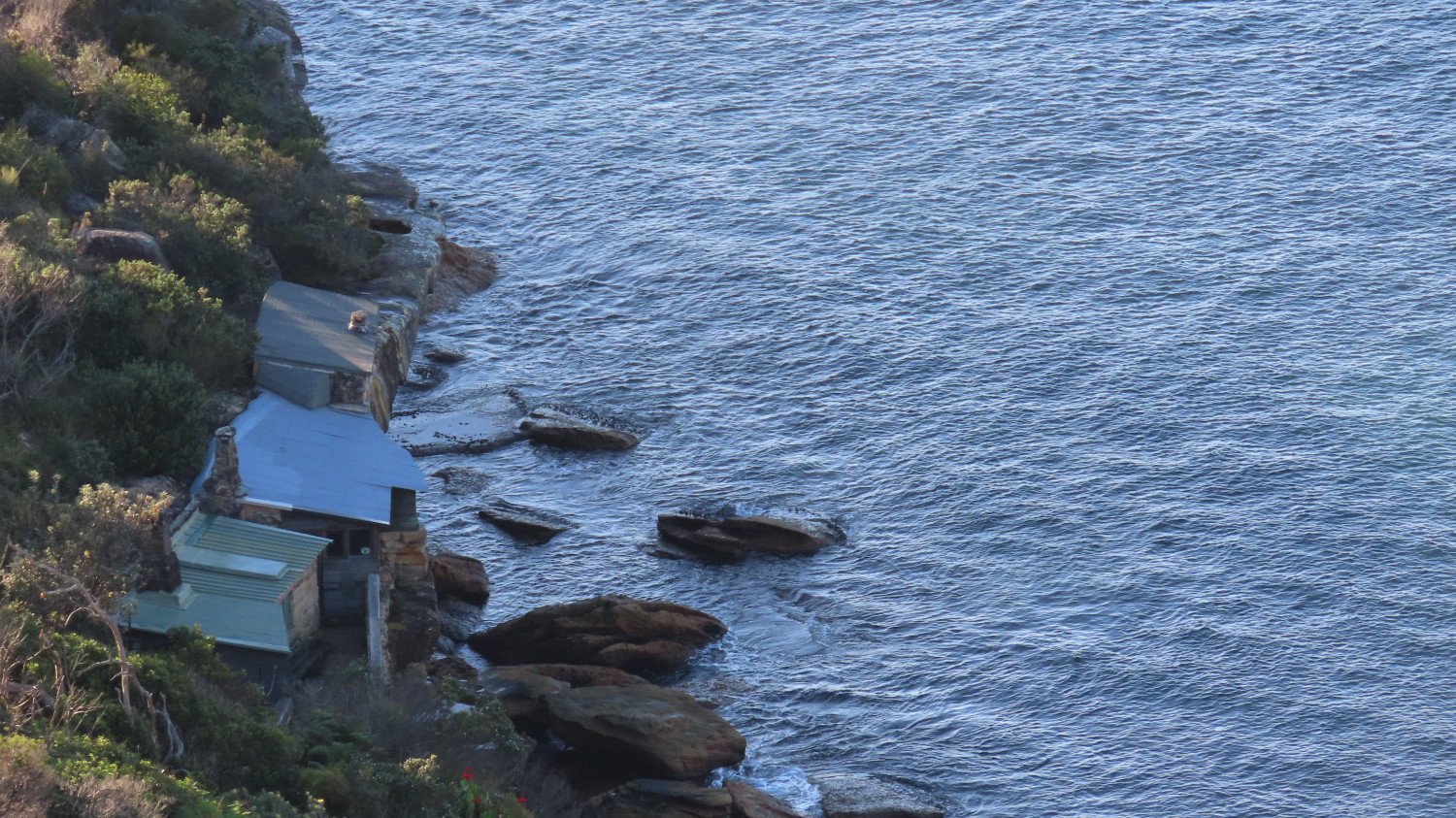
    Russ Grayson has published an intriguing account of his experiences with the huts over the years: Hidden paths: the lost settlement at Crater Cove. The first of the huts were built in the 1920s, and various groups of people have inhabited them over the decades. Now, however, the huts are boarded up. You can walk down and look through the windows, and stand on the rocks to gain a feeling for the place. The path down is somewhat hard to find, and the track disappears in places. But it’s well worth the scramble.

    This worm won’t go into the ins and outs of the huts’ story. Russ Grayson does that very well. Suffice it to say that the cottages have a long and interesting history.

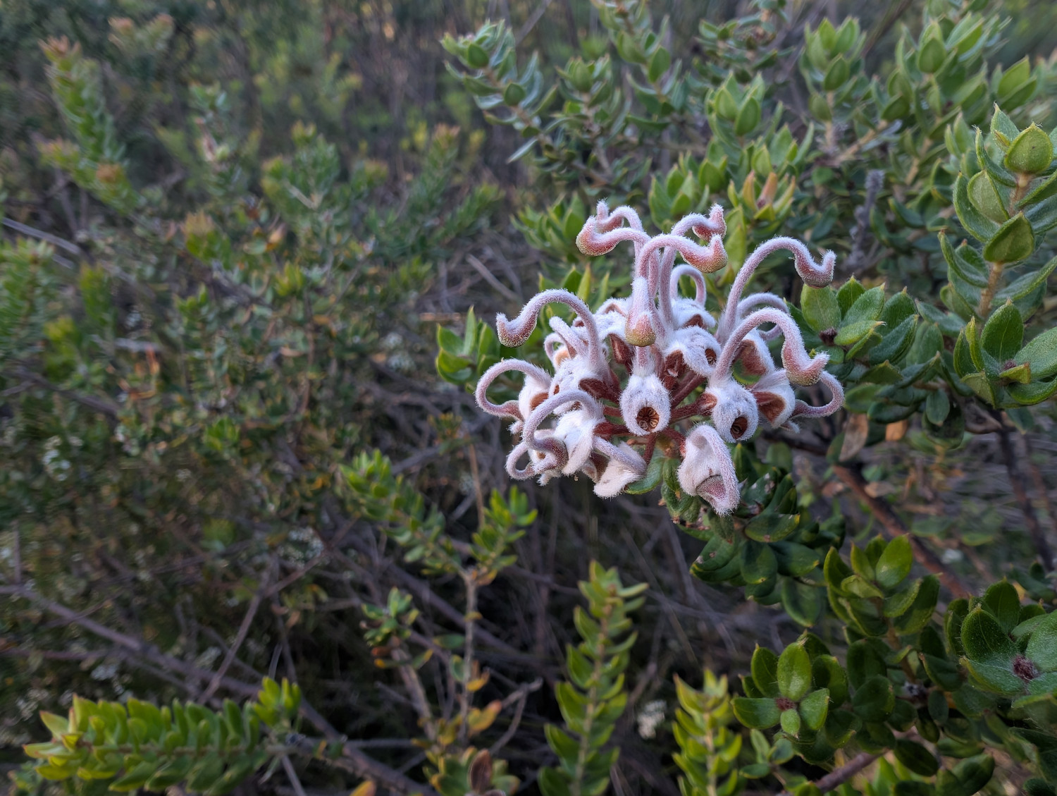
    What else will you see on the Dobroyd Head Walk? Plenty of native vegetation, including this Grey Spider Flower (Grevillea buxifolia). This worm doesn’t see the spider reference. Rather, the flower looks to me like a cluster of tentacled aliens who’ve landed on Earth and are screaming in horror:

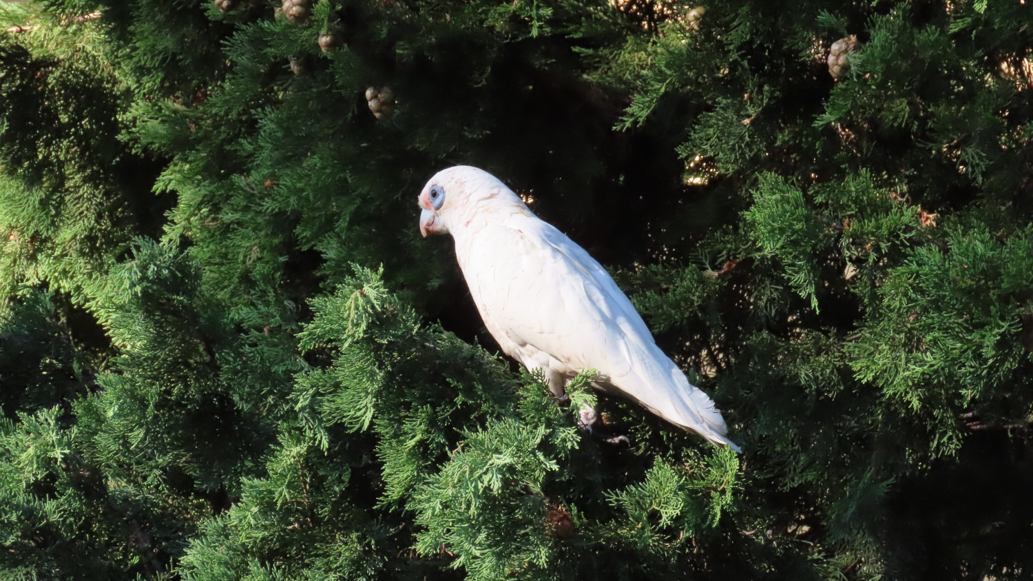
    There’s a plethora of birds, like this Corella:

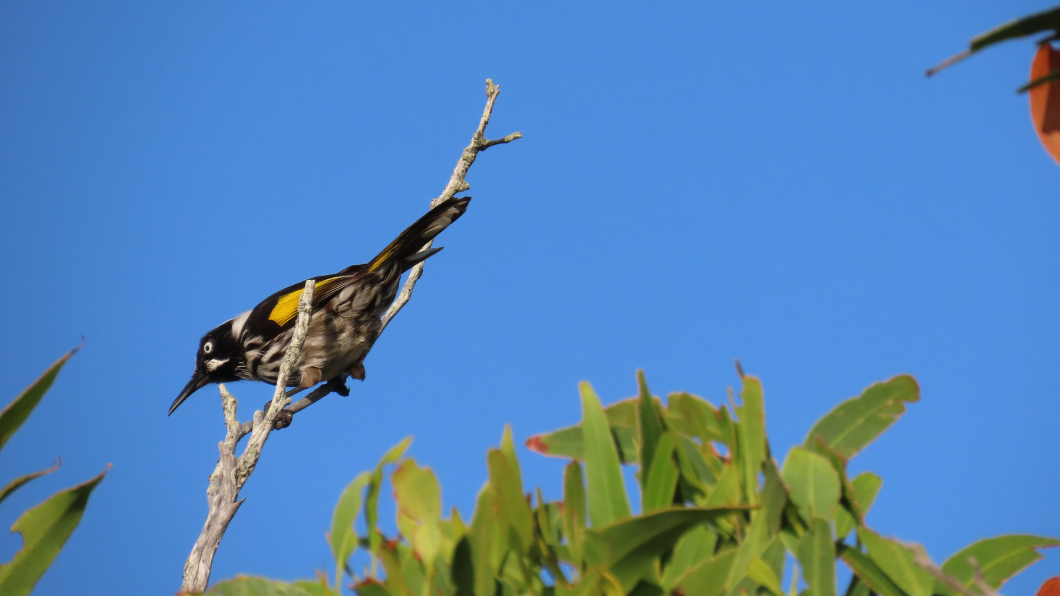
    And this New Holland Honeyeater:

    The TC, bless her clever grey cells, knows a lot about birds. Hence yours truly’s ability to name our feathered acquaintances so precisely. It goes without saying that yours truly stays well hidden during the bird-watching part of the expedition. Well away from all those scary beaks!

    For the brave souls amongst you: If you’d like to see more of the birds of this area, take a look at the TC’s blog, Sydney Birder. In particular, check out her posts about the birds she’s spotted at Forty Baskets and Dobroyd Head.

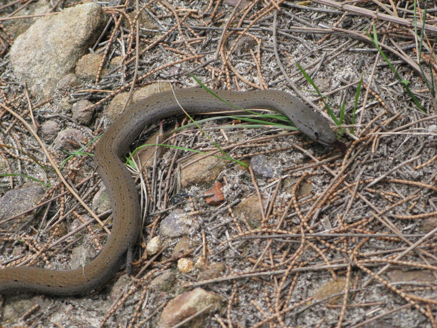
    Lizzie the Legless Lizard is much more my kind of person. We met her quite a few years back on Dobroyd Head. Although you might be tempted to yell snake, you’d be wrong. At some stage in the distant past, her kith and kin decided that legs were overrated. A close look reveals the stubs of legs that she’s left with:

    The lucky walker will also see wallabies, water dragons, butterflies and beetles, the occasional falcon, parrots and many many more birds, and perhaps even a snake or two.

    Have a good walk!

    Fediverse Reactions

  • Kangaroos boxing at Tom Groggin campground

    In this post: They look almost alien: male kangaroos fighting in the peace of the early morning. We’re at Tom Groggin campground on the New South Wales side of the Murray River.

    This is the blog of Mark Wordsworm, the travelling worm. I’m a 40-year-old bookmark (give or take a few years) and I proudly boast my own Hallmark serial number, 95 HBM 80-1. You’ll probably want to read all about me and my Travelling Companion (the TC).

    The upcoming video shows a lovely long scene of kangaroos in the early morning at Tom Groggin campground, on the banks of the Murray River, NSW. Two pairs of males practice their boxing skills. Nearby, a mother feeds her child. At around the 3:10 timestamp, one of the boxing kangaroos barks and huffs at the other a few times. It gesticulates with its arm and scratches its side, warning the other boxer off. Meanwhile, the other ‘roos carry on as normal:

    The kangaroos are well accustomed to people camping on the wide grassy spaces. After we set up camp, they came quite close and watched our activities with interest.

    A few horses came close too. The TC, bless her cotton socks, went all misty-eyed when she saw them, and talked of brumbies and The Man from Snowy River. We’re in the right area for all that, apparently:

    Let’s finish up with some still shots of those fighting kangaroos:

    A kick for good measure:

    How did we get to Tom Groggin? Check out my previous post: Crossing the Murray River – on the 4WD bucket list.


  • Crossing the Murray River: on the 4WD bucket list

    In this post: Crossing the Murray River is a 4WD milestone. The water can be deep, swift, and treacherous, or it can be a doddle. How was it for us?

    This is the blog of Mark Wordsworm, the travelling worm. I’m a 40-year-old bookmark (give or take a few years) and I proudly boast my own Hallmark serial number, 95 HBM 80-1. You’ll probably want to read all about me and my Travelling Companion (the TC).

    The TC, bless her adventurous cotton socks, has long wanted to cross the Murray River. Not the standard way, over a bridge. Rather, she yearned to drive across the river bed. Through the water. Over the rocks.

    The Murray is Australia’s longest river, stretching for 2,500 km (1,560 miles) from the Australian Alps in the east to the Southern Ocean in the west. It spends much of its time forming the boundary between the states of New South Wales and Victoria.

    When the river is in full flood, it’s fast and angry. At those times, driving across the river bed would not be a wise choice.

    We crossed from Victoria to New South Wales. The river was low and slow-moving. The crossing was easy and beautiful — a doddle:

    Before leaving Victoria, we took a look at the Dogman’s Hut and campground on the Victorian side of the river:

    There’s a perfectly usable drop dunny (Australian bush toilet) nearby:

    After exploring the site a bit, we decided to camp overnight at Tom Groggin, which is on the other side of the river.

    So, we crossed the Murray River, as shown in the video above. Here’s a photo of the Victorian side of the crossing, with a sign post helpfully pointing the way to New South Wales. The sign also advises us to Check Depth Before Crossing, skilfully avoiding the use of ALL CAPS but throwing in a few capital letters for good measure:

    What’s it like on the other side of the river, and what delights does Tom Groggin hold in store for us? Read my next blog post to find out.


  • Bombo Headland Geological Site

    In this post: The crashing seas and imposing rock columns at Bombo Headland Geological Site, south of Sydney on Australia’s east coast

    This is the blog of Mark Wordsworm, the travelling worm. I’m a 40-year-old bookmark (give or take a few years) and I proudly boast my own Hallmark serial number, 95 HBM 80-1. You’ll probably want to read all about me and my Travelling Companion (the TC).

    Today’s travel notes

    This worm has crawled past Bombo Headland several times, on past journeys heading south out of Sydney. Never before have I stopped to see what goes on in the area. A few days ago, me and the TC detoured off the beaten track (namely, the M1) to spend a couple of nights in Wollongong. During our stay, we took the small coastal roads down to Kiama, and on the way we stopped to see the headland.

    The book I’m in

    The Between by Tananarive Due. The TC has only recently discovered this amazing author. Already, we’re more than half way into our second book of hers, and the TC has bought four more. Count ’em, four! Tananarive Due writes beautifully-composed horror. Get into one of her books as soon as you can.

    Travel tips

    Take a detour from the highways whenever time allows.

    The photos

    Me at Bombo Beach:

    A short walk from the beach, the waves churn and crash between the rock formations at Bombo Headland Geological Site:

    A still photo of the same spot captures the watery turmoil:

    The tall, squared-off columns of rock are imposing. The rocky ground beneath the rocks is quite bare, and glares in the hard sunlight. Combined with the churning seas, the effect is a little threatening. Definitely eery.

    The columns are made of basalt and have a distinctive hexagonal shape, formed during volcanic eruptions 270 million years ago. Basalt is a hard igneous rock that’s produced when lava cools rapidly.

    If you walk around behind the rock towers, the scene is more tranquil. A shallow pool lies quiet in the sunlight:

    The occasional wave bounces high enough to breach the gap in the rocks and refresh the pool:

    The TC, bless her slightly wet cotton socks, posed in front of another gap. She waited patiently for that Internet-favourite shot with the waves crashing behind her:

    Here’s the same Internet-famous spot, without the TC this time:

    Fediverse Reactions

  • The Big Koala & The Dog on the Tuckerbox

    In this post: The Big Koala, The Dog on the Tuckerbox, and a fearsome Fairy-wren, all near the New South Wales country town of Gundagai.

    This is the blog of Mark Wordsworm, the travelling worm. I’m a 40-year-old bookmark (give or take a few years) and I proudly boast my own Hallmark serial number, 95 HBM 80-1. You’ll probably want to read all about me and my Travelling Companion (the TC).

    Today’s travel notes

    On our way to the Victorian High Country, me and the TC stopped for a short break in the country town of Gundagai. The town is a popular stopping place on one of the main routes to the border between New South Wales and Victoria.

    Just outside the town, we met a big koala, a dog perched on a tucker box, and a bird that sits still for no-one.

    “What’s a tucker box,” you ask? It’s a lunch box. Nowadays, Australians carry their food around in an esky rather than a tucker box. “Esky?” That’s a cool bag or ice box, named after “eskimo”.

    The book I’m in

    The Phenomenon of Man by Pierre Teilhard de Chardin. Yes, the TC is putting me in some heavy stuff. We’ll see how this turns out.

    Travel tips

    When driving the Australian highways, take a turnoff and see where it leads.

    The photos

    Me and the Big Koala near Gundagai:

    It was, errm, interesting being so close to those claws. Yours truly survived by dint of keeping a low profile. That’s easy to do when you’re two-dimensional. Just turn sideways on.

    There are “big somethings” dotted all around Australia. This worm has already met the Big Bogan at Nyngan and the Kurri Kurri Kookaburra. Now the Big Koala. No doubt the TC, bless her itchy feet, will go in search of more big somethings.

    A few million steps from the Big Koala (a few million, that is, if you’re a small worm like yours truly) is the Dog on the Tuckerbox:

    The plaque below the dog and the tucker box declares the statue to be a tribute to the pioneers of Australia, unveiled in 1932.

    A rustic sign post tells the story:

    Ironically, as far as I can tell, the dog that features as the hero of this monument was probably based on lyrics by Charlie ‘Bowyang’ Yorke, who wrote a far less clean poem than the two shown on the sign. In Charlie’s story, the dog did a poo on the cattleman’s tucker box.

    I’ve used a more polite word than the original poem, to protect tender ears. You can probably guess the original word: it rhymes with “sat“, which is now used as a replacement in the poem.

    What’s more, the dog chose his moment when the cattleman was battling through the hardest of times: his wagon was bogged, the axle snapped, the team of bullocks stuck, and rain starting. The unfortunate cattleman couldn’t even dry his trousers or boil a pot of tea.

    On to prettier things:

    In using the word “pretty”, yours truly is of course referring to the lichen on the twigs, not to the beady-eyed creature perched above. That’s a baby dinosaur, known to some as a Superb Fairy-wren, and it eats people like me for breakfast. I stayed hidden in my book while the TC ooh-ed and aah-ed over the monster.

    I’ll be back soon with more news about our trip to the Victorian High Country.


  • Fitzroy Falls and Meryla, NSW

    In this post: Meryla Flora Reserve, Morton National Park, and the Fitzroy Falls in New South Wales, Australia. Plus wombat poo, plant snot, a cicada husk, a predatory lyrebird, and a somewhat dark ending.

    This is the blog of Mark Wordsworm, the travelling worm. I’m a 40-year-old bookmark (give or take a few years) and I proudly boast my own Hallmark serial number, 95 HBM 80-1. You’ll probably want to read all about me and my Travelling Companion (the TC).

    Today’s travel notes

    Me and the TC set out to explore some 4WD tracks around Meryla. We discovered that all the dirt tracks were closed to vehicles, due to environmental concerns and track repairs. It’s a beautiful area, so we drove around on the sealed roads instead, exploring parts of Meryla Flora Reserve and the Fitzroy Falls in Morton National Park.

    The book I’m in

    Machinehood, by S.B. Divya. This is the second book by this author that the TC has put me in, and I’m enjoying it just as much as I enjoyed the first (Meru). Divya has created an interesting and exciting mix of philosophy and science, resulting in an excellent SciFi story.

    Travel tips

    Take your own picnic, so that you can stop wherever you like to enjoy the scenery and the peace.

    The photos

    Me at Fitzroy Falls:

    We started our explorations in Meryla Flora Reserve on one side of Morton National Park. The day was misty, which added to the beauty of the forests and valleys.

    The TC, bless her cotton socks, was taking great care to avoid all the poo on the ground. A closer look through the camera lens revealed that it wasn’t poo:

    Nor was it seaweed. We were far from the coast. No, it’s a type of cyanobacterium (Nostoc commune), fondly known as plant snot. People also call it star jelly, witch’s butter, and mare’s eggs. It’s found world-wide. The part that you see is a sheath made of jelly. The bacteria live inside the sheath, and can form large colonies.

    So that’s what the TC was traipsing through. It’s a good thing she was careful, as plant snot is very slippery when it’s wet, as it was here. In long dry spells, it dries out and waits for rain.

    To her delight, the TC did encounter some actual poo, perched neatly on a rock:

    Poo-bearing rock is a fairly common sight in the Australian bush. Evidently wombats, the makers of these monuments, deposit their offerings on a rock as a mark of territory. He who poos highest has the most influence in terms of spreading scent and being seen.

    We left Meryla Flora Reserve and made our way to Fitzroy Falls, on the other side of Morton National Park. The waterfall is 81 metres high, formed by the Yarrunga Creek dropping into Kangaroo Valley. To get an idea of the scale, notice the people on viewing platforms on the left and right of the falls in this picture:

    This is a view of the valley. The falls are off-camera on the left:

    It’s worth walking along the trails on either side of the falls. This lovely old eucalypt, nicknamed The Knobbly Tree, is on the Western Rim Walking Track:

    Of course, the TC insisted on a pic of yours truly cuddling up to the tree, in spite of the scary-looking spider webs that covered the bark:

    Imagine the spider that lives in the hole sunken into that web. I’m sure this would be a case of its bite is worse than its bark.

    A tranquil view of the falls from afar restored my je ne sais quoi:

    Not far away, another peril lurked: a lyrebird scratched through the dirt looking for grubs and chatting to its friend. While the TC ooh-ed and aah-ed, this worm stayed far away from the modern-day dinosaur:

    When in natural surrounds in Australia, it’s always worth looking under the picnic table.

    Here comes the dark ending that I promised at the start of this post. The TC noticed this cicada husk under the picnic table:

    More disturbing, and a caution to an unwary worm, were the pieces of cicada lying on top of the table:

    This worm does hope that the cicada who emerged from the husk had time to enjoy life above ground, and that it was another poor insect who fell prey to a bird.


  • Dixons Long Point Crossing 4WD

    This is the blog of Mark Wordsworm, the travelling worm. I’m a 40-year-old bookmark (give or take a few years) and I proudly boast my own Hallmark serial number, 95 HBM 80-1. You’ll probably want to read all about me and my Travelling Companion (the TC).

    Today’s travel notes

    Me, the TC, and Beetle the Jeep spent a night in the historic town of Hill End, New South Wales. Early the next morning, we set out to cross the Macquarie River at the well-known Dixons Long Point Crossing.

    The book I’m in

    Meru, by S.B. Divya. Excellent SciFi about a human and an alloy who fall in love, and about an experiment with human life on planet Meru. Alloys are post-human beings who share human and AI genes.

    Travel tips

    You’ll need a 4WD vehicle to complete this trip, because of the river crossing. It’s also good to be aware that the Macquarie River is a large river that can carry a significant volume of water after rain. It can be deep and the current can be strong enough to wash away cars and caravans. Always check the conditions before attempting the crossing.

    The photos

    Me at Dixons Long Point Crossing:

    It’s a trifle tricky to decide which line to take when crossing the river. We were driving from the Hill End side to the Bathurst side. The TC had watched several videos of other people making the crossing. The consensus of opinion seems to be that you should cross on the rougher side of the rocks, not the smooth side. Basically, follow the line between the two rows of rocks. That’s what we did. It was bumpy but fun, and the river level was low at the time we made the crossing.

    On the other side, the TC, bless her cotton socks, struck up a conversation with a man who looked as if he knew the area. He said that originally, the intended line was on the smooth side of the rocks, where a causeway had been built. But then a flood moved most of the rocks down off the causeway, which resulted in a deep hole at one end. The hole is about the length of many vehicles’ wheelbase, so you can get stuck, especially if the vehicle doesn’t have much clearance. The rougher line is now the recommended route, although it’s basically bedrock.

    Let’s back up, now that you’ve seen the crossing, and start at the beginning of the day’s trip…

    A night in Hill End

    Before starting the drive to Dixons Long Point, we spent the night at Hill End Lodge:

    The photo shows the reception area and restaurant of the lodge. We stayed in one of the cabins nearby. Early the next morning, the TC went for a stroll and came across a group of kangaroos. Most of them fled, but a big male stayed to keep watch, along with couple of others, one of which was a female with a joey in her pouch:

    The TC, wise soul, decided that discretion is the better part of valour, and altered direction to keep away from the roos.

    After breakfast, we paid a quick visit to the town of Hill end:

    The Royal Hotel is another good option for an overnight stay in the town:

    Golden Gully

    We headed north up Hill End Road towards Ullamulla Road, and came across the enchanting Golden Gully:

    Holes small and large pepper the eroded walls of the canyon. Many of them lead to shafts and tunnels dug by hopeful gold miners in the 1850s. The gold in this area is alluvial, washed down in several creeks that feed into the gully.

    You can walk down the gully to the point where a sign warns of danger:

    Ullamulla Road and Dixons Long Point

    Me at the junction of Hill End Road and Ullamulla Road:

    A sign warns of the nature of the upcoming crossing:

    The road itself is an easy drive:

    A sheep with a new-born lamb greeted us:

    The next video shows the descent towards Dixons Long Point Crossing, on the Hill End side. At about 30 seconds into the video, a wallaby hops across the track in front of the car:

    We stopped for a photo opp when we reached the water:


  • Coxs River & Six Foot Track 4WD

    This is the blog of Mark Wordsworm, the travelling worm. I’m a 40-year-old bookmark (give or take a few years) and I proudly boast my own Hallmark serial number, 95 HBM 80-1. You’ll probably want to read all about me and my Travelling Companion (the TC).

    Today’s travel notes

    Me, the TC, and Janet the Jeep recently drove across country in the Blue Mountains area, from Little Hartley to the Jenolan area. The trip included Coxs River Road, Ganbenang Road, Cullenbenbong Road, Glen Chee Road, Six Foot Track, and Black Range Road.

    The book I’m in

    No Time for Goodbye, by Linwood Barclay. A psychological drama packed with plot twists. Much like a 4WD road.

    Travel tips

    You’ll need a 4WD vehicle for most of this trip. The first part, before the turnoff to Coxs River camping ground, is fine for 2WD vehicles. But you’ll need a 4WD to get down to the camp site, and then back up again to follow the rest of Glen Chee Road.

    The photos

    Me at Coxs River camp ground:

    The TC, bless her woollen mittens, decided to focus on the river rather than on yours truly. Sometimes I disagree with her choices.

    We started our trip at the Little Hartley end of Coxs River road. The first hour or so is a lovely, meandering route, part sealed and part dirt. The views are of rolling hills and dales. And cows. This shot is from a trip last year:

    At the camp ground, Coxs River is wide and rippling:

    Looking in the other direction, the river widens out into tranquil pools:

    We took a walk from the camp ground towards Bowtells Swing Bridge. This is a 20-minute walk through the forest, with views of the river gorge on one side:

    Bowtells Swing Bridge is currently closed for maintenance. It’s been so for a long while: years. This worm has never seen it open. Crossing the bridge could be a wild ride, swinging over a deep river canyon:

    If you turn left when you come up the road from the camp ground, you enter the 4WD-only part of Glen Chee Road:

    See what it’s like driving Glen Chee Road near Pass Gully. This clip shows some track erosion, but it’s an easy drive when dry:

    Further along Glen Chee Road, descending towards Alum Creek Camping Ground:

    The road leads through pretty forest:

    Despite it being mid winter when we made this trip, yellow flowers were sprinkled across the bushland:

    In the next video, we cross Little River. This is one of several river crossings on the trip. They’re not hard, provided the river is low and your vehicle is a capable 4WD.


  • Old Grafton Road and Dalmorton Tunnel, NSW

    This is the blog of Mark Wordsworm, the travelling worm. I’m a 40-year-old bookmark (give or take a few years) and I proudly boast my own Hallmark serial number, 95 HBM 80-1. You’ll probably want to read all about me and my Travelling Companion (the TC).

    Today’s travel notes

    Me, the TC, and Janet the Jeep took the long way round from Sydney to Brisbane, to explore a bit of the inland countryside. On the second day of our trip, we drove from Glen Innes to Grafton via Old Grafton Road and Old Glen Innes Road. This is a beautiful route. The road is partly sealed (bitumen) and partly unsealed (gravel and clay). It’s in good nick all the way from Glen Innes to Grafton.

    Read on to get a feel for this trip.

    The book I’m in

    Force of Nature, by Jane Harper. A book that starts well and gets better and better.

    Travel tips

    It’s most comfortable to travel from Glen Innes to Grafton, rather than in the opposite direction. The road is narrow, the edges unguarded, and the side falls away steeply along much of the way. If you’re on the side that drops off, it can be uncomfortable when you meet a vehicle coming towards you.

    Recommended accommodation

    Apartments on Grey in Glen Innes. Warm and cosy, with everything you need for a comfortable stay.

    The photos

    Me at the turnoff to Old Grafton Road on Gwydir Highway:

    The first part of Old Grafton Road is sealed (bitumen). But don’t be fooled! It’s scenic — meaning, it’s steep, winding, and narrow. This video gives a taste of the road. Part way through (at the time stamp of 40 seconds to 1:03), the TC stopped the Jeep to take a shot of three wallabies on the side of the road:

    The road descends swiftly to cross Diehard Creek:

    A helpful soul has posted warning signs along the road:

    Mann River Nature Reserve is a pretty spot to take a breather:

    Janet the Jeep was raring to go when Old Grafton Road changed to dirt:

    At times, you’ll come across an entrance to a family farm:

    Here’s another homestead, further along the route:

    Much of the road runs alongside Boyd River. Sometimes it’s at the level of the water, sometimes high above. It’s narrow and slippery — take care!

    Just around a corner, you’ll come across Dalmorton Tunnel. The tunnel is 20 metres long, 4 metres wide, and has a height clearance of 3.2 metres.

    Me at Dalmorton Tunnel:

    The tunnel was built in the 1860s by civilian contractors. (Some reports say that convicts built it, but that’s probably apocryphal.) The tunnel was blasted out of solid rock, then trimmed with hand tools. (Again, some reports say it was “hand hewn”, but that’s probably not completely accurate either.)

    Here’s Janet making her way through the tunnel, hogging the limelight as she does:

    Boyd River offers some picturesque spots for coffee and a photo:

    Next is a cow closeup, for people who like cows. This worm avoids them, as they’re apt to put those big feet where they’re not wanted. But the TC, bless her cotton socks, liked the way this cow was cosying up to the pink bush:

    On Old Glen Innes Road, a wide, low bridge crosses the Nymboida River:

    Scattered around, in the water and on land, are sections of a huge pipe, filled with concrete:

    Perhaps the pipes formed the scaffolding of a previous bridge? Who knows:

    The TC, bless her woollen mittens, is keen to finish off with some shots of the road. So, for those enthusiastic road-farers out there:

    See you on the road!


  • Standing stones at Glen Innes

    This is the blog of Mark Wordsworm, the travelling worm. I’m a 40-year-old bookmark (give or take a few years) and I proudly boast my own Hallmark serial number, 95 HBM 80-1. You’ll probably want to read all about me and my Travelling Companion (the TC).

    Today’s travel notes

    Me and the TC recently spent a night in Glen Innes, NSW, on our way to Brisbane. Early the next morning, we dropped in on the standing stones before continuing our journey.

    The book I’m in

    Force of Nature, by Jane Harper. The TC recently read The Dry by the same author, and enjoyed it so much that she resolved to read more of the author’s work. This worm is pleased. The book is an exciting, comfortable place to be.

    Travel tips

    The Australian Standing Stones are not to be found in the little village of Stone Henge, which is nearby. The village of Stone Henge is worth a visit too, surrounded as it is by stones and boulders, including some interesting formations of stones perched on top of others.

    The official standing stones monument is in Glen Innes.

    Visit the standing stones early in the morning if you can. They have a certain drama when the sun is low in the sky.

    Recommended accommodation

    Apartments on Grey in Glen Innes. Warm and cosy, with everything you need for a comfortable stay.

    The photos

    Me with some of the standing stones at Glen Innes:

    An early morning view of the ring of stones:

    An engraved stone in the middle of the ring describes the design of the stones, placed to catch the sun’s rays at key times of the year:

    These standing stones don’t pretend to be ancient. They were erected in the late 20th century and dedicated in 1992, as a tribute to the various Celtic nations who’ve settled in and contributed to Australia’s history.

    Near the top right of the next view of the stones, there’s a line of flag poles, one from each of the nations that has contributed to the monument:

    On the edge of the ring of stones is a rather attractive, though fake, Excalibur — complete with injunction to try to pull it out of the stone and thus gain great knowledge and wisdom:

    A wall curves round the path, embedded with gifts of stone from various sponsors of the monument:

    Here’s one of the embedded stones with its inscription. This worm likes the simple attractiveness of the stone:

    More stone dedications: